More Megalithic Musing

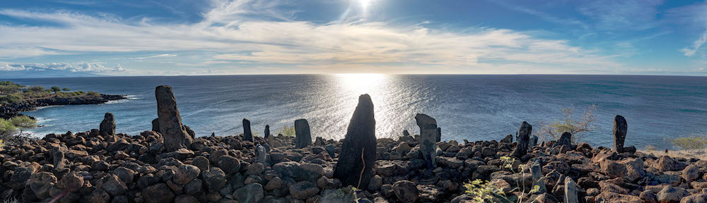
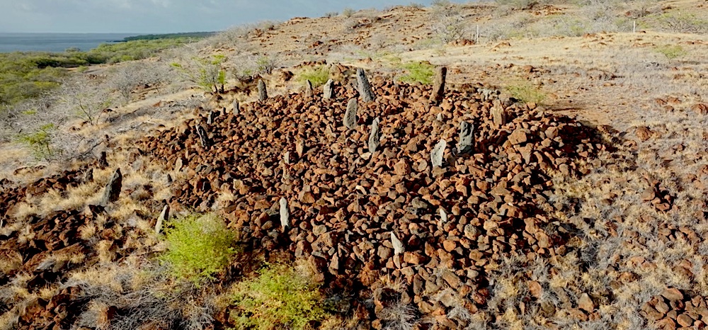
My last post about the navigational Heiau called Ko’a Holomoana in Hawaii made me notice another megalith that could be described as “navigational”. Although the scale of the map it appears to refer to is not as wide as the Pacific Ocean, it nonetheless describes a large area.

In this post, I will be making a case for “Les Menhirs de Lutry” as a geographical alignment. This megalith is made up of large and not so large stones on the shore of Lake Geneva (or Lac Léman, which is how it is called in the area, a name that dates from the Romans – ‘Lacus Lemannus’ – from a couple of thousand years ago). As I understand, no one has ever published this interpretation, but it seems to be an oversight, and should at least be contemplated as an explanation of its unique layout.

Megaliths come in many shapes and forms, and their interpretations are a part of guesswork and careful investigation of their geographic situations. There are two main categories that often overlap: they can be ceremonial, such as for a burial or place of ritual; and/or cosmological in their intent, meaning they are astronomical alignments which are in use as a calendar where the heliacal rising and setting of stars is marked, and allows for the study of the motion of planets, stars, the Sun and our Moon.

The finding of the navigational Heiau in Hawaii, and now the possible representation of this alignment of stones in the town of Lutry might elude to a third category, which could be named “geographical” or geodetic. 

Full disclaimer: obviously, I am not trained as an archeologist. I am just curious about astronomical alignments that megaliths often demonstrate. This kind of cosmological stone construction is most often found in two typical layouts: rings or circles (like Stonehenge in England), or straight lines which are often parallel (like Karnak in Normandy). The stones in Lutry are loosely aligned with the summer and winter solstice, but their alignment falls in between the two typical layouts – the Lutry megalith stones are placed in a row; but at some point they bend to the south, as you can see in the image below:

Layout of the stones at the “Menhir de Lutry”

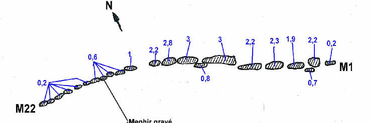
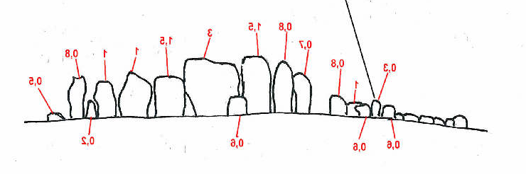
Secondly, there is a vertical progression, as the eastern part is composed of larger and taller stones that progressively get smaller as it moves to the west and starts bending to the south, as shown in the next image:

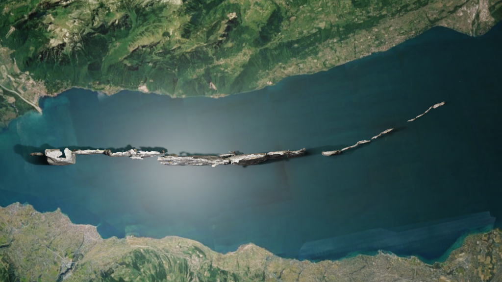
The alignment is on the shore of Lac Léman, and across this body of water, a large massif of Prealps mountains dominate the horizon. Unfortunately, due to the fact that the monument sits in the middle of a small town, this imposing view is obscured by houses and therefore separates the geographical features that these stones are representing. In order to recreate the original setting, I scanned the alignment and placed it in plain view of the landscape as it would have been originally. I removed the houses and placed the monument as it would have looked when it was built:

“Menhir of Lutry” with Building removed

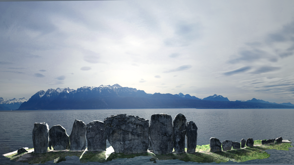
Each stone matches a large mountain block, and as the mountains recede, the stones get smaller. There are two stones that must have been lost through time. When we take a different view from above, there is more that matches the geography. As we see in the plan above, the stones bend to the south as they get smaller. This replicates quite accurately the natural bend along the south shore of the lake as it it moves to the west. To highlight this, I have highly magnified the stones to show how accurately they match the curve of the lake.

Les Menhirs de Lutry” from above (the south shore of the lake is on the top of the image)

Here is another view from the south

“Les Menhirs de Lutry” view from the south and at an angle  (the north shore of the lake is on the top of the image)h

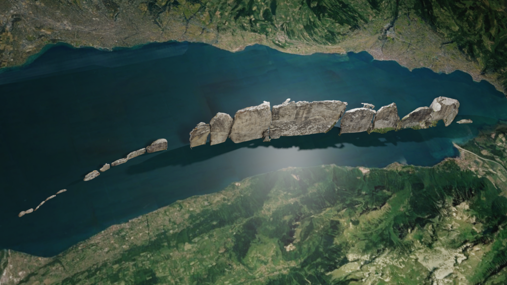
These two montages highlight the close match between the alignment of the stones with the shoreline of the lake. The combination of the silhouette view of the mountains as shown in the first montage with the stones matching the curvature of the shoreline shown from above in the second and third, reinforces the theory of intentional map making.

The question then arises: why would the builders of this megalith need to build such a representation of the mountains and lake shore on their side of the lake? Obviously, we don’t know; so I ask myself, why do we use maps at all? Especially such a large map that obviously we cannot fold and transport in our backpack? These kinds of maps are used in situations (i.e. situation room) where we need to plan some kind of collective action: hunt, prepare for war, celebrations, exploration – where you want to coordinate and plan the movement of a number of people.

It could also be that these mountains and this lake have mythical meaning to the megalith builders, and to recreate it in a more manageable scale, it allows them to have some control over the elements. The alignment seems to not have any particular astronomical alignment – it does not face east or west, where most celestial movements occur and are more obvious.  

So, is geographical mapping a category for these megalithic structures? I first experienced one, as I mentioned above, when visiting the navigational Heiau on the Island of Hawaii, a megalith that maps the major islands of the Pacific Ocean. It seems to me that Les Menhirs de Lutry appear to follow that pattern. If this theory holds, it shows that the builders of these ‘geographical megaliths’ had some impressive geodetic knowledge and abilities.

A Cosmic Misunderstanding

Navigational Heiau called Koʻa Holomoana

During my second trip on the Big Island of Hawai’i, a trip that turned out to be as spectacular as the first one, was made quite unique by the fact that the Mauna Loa volcano started erupting the day we arrived. This made me quite happy, especially since the weather predictions were not looking too good for the week. If I was not able to see and photograph the fire in the sky (i.e. stars), I would get to see it coming out of the ground. But this post will not be about this event, but about the ongoing controversy regarding Mauna Loa’s neighbor volcano Mauna Kea and the telescopes sitting atop it decoding the universe.

Mauna Kea with the observatories at the top

At the time of our first trip we got to visit two of these “big eyes” (the Keck and the Infrared telescope). We were made aware of the tension that had arisen between the astronomy community and the native Hawaiian community around the building of a new large instrument Named the TMT (Thirty Meter Telescope) that would be added to the top of the mountain. In an act of protest, a group of native Hawaiians blocked the access road as the first construction trucks attempted to reach the summit.

The Thirty Meter Telescope (TMT)

The source of the dispute has many layers, but the underlying reason comes from the fact that Hawaiian natives have been dealt a most unfair deal by the United States. First, as in many other instances, by taking over the Islands and secondly, by forcibly making Hawai’i a part of the United States without asking the opinion of its future citizens. These actions had the consequence of diluting and marginalizing the original Hawaiian culture. So when the planning of the TMT (as well as for the current collection of observatories) was put in motion, no effort was made to include the local population in the discussion and planning. This ignited a longtime resentment and a feeling of cultural subservience to the “Western World” embodied by the invasion of the summit, which they consider sacred.

Mauna Kea with the glow of the Mauna Loa eruption

In recent years, the astronomical community has realized that there would be no possible agreements on the matter until an effort of outreach was made, and has begun to remedy the problem with educational efforts and acknowledging Hawaiian culture by naming objects discovered by observatories on the mountain in the native language (‘Oumuamua, our recent outer-solar visitor being the most famous). But a vocal minority has not yet accepted the construction. They view the collection of observatories as desecrating their holy mountain for an application that does not concern them. The top of the volcano represents their connection with their gods, and the connection of two worlds: Earth and the Heavens.

But Is there no possibility that the native Hawaiians can find a path to accept the observatories in a way that coincides with their tradition and cosmology?

I think there is, and I propose that by looking at the past history of the islands, and by a study of the lost Hawaiian knowledge of the stars and geodesics, it can be demonstrated that these two cultures both have the same goal in mind and that their achievements are not so far apart.

On the west coast of the Big Island sits a unique monument, a navigational Heiau called Koʻa Heiau Holomoana. A Heiau is a temple or place of worship where native Hawaiians held ceremonies. Several Heiaus were destroyed at the official end of Hawaiian religion (Kapu system) after the Battle of Kuamo’o in 1819 and the long shadow of influence by Christian missionaries. There are many Heiaus on all the islands, but, as far as I know, none that resembles this unique one.

This picture shows clearly the curve of the hill at the Navigational Heiau

The monument consists of a series of upright stones, not unlike megaliths found around the world. Each stone serves as a unique marker that points to the direction of an island in the Pacific Ocean. Early Polynesians were guided by an intricate navigational system using the constellations, and it is how the first inhabitants of the Hawaiian Islands (about 1500 years ago) sailed to them. This knowledge has been lost to modern day Hawaiians, although it is enjoying renewed interest in recent times.

Navigational Heiau from the road

Unfortunately there are no studies that I could find about this Heiau. The only information I found comes from a great guide book about the island by Andrew Doughty, who investigated the monument and connected the stone markers with specific islands in the Pacific, using GPS data and aerial photography to reveal the alignments (in the app accompanying the book he tells a pretty interesting story about his investigation).

I visited the Heiau last month, and it was a bit difficult to find as there are no markers indicating the path to it, but you can see it from the highway – so on the second try we found it. The Heiau sits on a round hill overlooking the ocean, an unlikely spot for a Heiau, as all the ones I am aware of seem to sit on a flat surface. As I was looking at it trying to imagine how it could have been used by the ancient navigators, I realized while looking at it from the back of the monument facing the ocean that I could not see all the markers, as some were hidden by the curvature of the hill. It took me a while, but back in New York while working on the photos I took that day, it hit me: what the curvature of the hill recreated was the curvature of the Earth! So it is a 3D representation of the Pacific Ocean.

A 3D scan of the Navigational Heiau

Well, these are conjectures on my part, but it makes it pretty clear to me that the ancient Hawaiians must have been aware that the Earth was round. As it was already known, they were aware of the motion of the stars in the heavens, but in this instance it seems that they were able to make a model of it. This knowledge is evidence of very careful observations made over many centuries traveling throughout the Pacific Ocean. In this there is a direct connection between the observatories atop Mauna Kea. In fact, knowing about the curvature of the planet is a prerequisite in order to understand our place in the cosmos and to be able to map it. 

As I mentioned earlier, most of that navigational knowledge has been lost. To rediscover it and promote it would go a long way in harmonizing traditional and western cultures using a community of goals with a variety of means.

Link to the Mahukona Navigation & Ecological Complex site

Department of Land and Natural Resources of Hawai’i
Office of Conservation and Coastal Lands

About the Thirty Meter Telescope