When the exact longitude differences between Europe and United States was to be measured, the only possible way was to put down electrical telegraph cable underwater. So far these measurements were made with chronometers, but at best with about a four second inaccuracy. So beginning in August 1857, this mission had to struggle against the north Atlantic to lay a telegraph line under water. Cable broke again and again. One ship sank, and civil war interrupted the process. Finally on December 11, 1867, the message got through, and finally at the two extremes of the continents: the island of Valencia on the western coast of Ireland and at the other end on the island of Hearth’s Content of Newfoundland, the weather, known to be mostly rain and gale, cleared just long enough on both sides to allow for a simultaneous celestial measurement. Thanks to the light speed of the electromagnetic signal through the wire, the exact distance between the two continents could be accurately measured: an analog signal, I might add.
These underwater cables had a tendency to sever themselves in the middle of the length of the ocean; somehow the assumed smoothness of the ocean floor was broken in the middle. It was found that the cable had to traverse a range of underwater mountains that rose 2000 meters above the sea bed.
The next development comes during the world wars, when the fear of U-boats resulted in the English and Americans developing Sonar technology. This technology works by continuously timing the reflection of high-frequency sound waves from the seafloor: since the speed at which the sound waves travel in water is known, the distance to the seabed or object can be calculated. (Sound waves travel faster as the density of the medium they are going through increases; I have an earlier blog musing on the subject.)
So in the 1950’s, a detailed picture of the ocean floors was emerging from sonar surveys. It was discovered that the mid-Atlantic Ridge, traversed by the first telegraph cable, was just part of a 40,000 km-long chain of underwater mountains running around the globe. When drill cores were retrieved from the ocean floor, the whole of the sea floor was found to be geologically very young. Much more so than the continents. Furthermore, the rocks were getting older as they were further away from the Mid-Atlantic ridge (as the mountains at the center became to be called).
The conclusion was that new ocean floor was being created continuously, leading in the 1960’s to the acceptance of the theory of Continental drift (so much for those that thought that the 60’s was only about sex, drugs and rock ‘n roll). This reveals the transitory nature of the kind of measurements I described at the beginning of this post – of course at a geological, not a human scale.
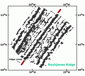
This finally leads me to the point of this post: it turns out that the length of these thousands of miles of new ground was recording the many switches of the Earth’s magnetic poles (the magnetic poles switch from time to time, not the geographical ones). The seafloor would, therefore, be acting like a double tape recorder, advancing in both directions from the ridge, producing strips of rock magnetized alternatively in normal and reversed direction, and symmetrically arranged about the ridge, the width of each strip would be determined by the length of the polarity interval and the rate of seafloor spreading.
There you go – the oldest analog magnetic recording on Earth, as old as the last time the East coast of the United States was joined to West Africa, a good oh, give or take 300,000 million years ago. But since it is all in motion, all this good recording will be recycled when it subsides under the continents, to make room for the new hits of the next eons.
